


Le Vaudoué-variante_6815613

gdela
User
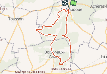

Length
16.4 km

Max alt
130 m

Uphill gradient
223 m
Km-Effort
19.3 km

Min alt
68 m

Downhill gradient
224 m
Boucle
Yes
Creation date :
2020-09-09 15:56:26.064
Updated on :
2020-09-09 16:33:58.744
--
Difficulty : Very easy

FREE GPS app for hiking
 SityTrail
IGN / Geographical institutes
SityTrail Plus
The world is yours!
About
Trail On foot of 16.4 km to be discovered at Ile-de-France, Seine-et-Marne, Le Vaudoué. This trail is proposed by gdela.
Positioning
Country:
France
Region :
Ile-de-France
Department/Province :
Seine-et-Marne
Municipality :
Le Vaudoué
Location:
Unknown
Start:(Dec)
Start:(UTM)
464383 ; 5355858 (31U) N.
Comments